The Silver Stallion: Cabellian Arts
Maps of Poictesme and the Geography of Dream
Hall Code |
Description |
*G13 [A11] |
|
G2 |
|
G8 & G12 |
|
G10 & G11 |
 Any fantasy writer who creates a new landscape of any complexity soon discovers the need for a map of the new realm, simply to keep things straight. James Branch Cabell was no exception to this rule. In "A Note Upon Poictesme", his introduction to the 1928 illustrated edition of The Silver Stallion (Hall SS-D1, revised and reprinted in Preface to the Past, Hall Pref-A1), he stated that his original reason for inventing his own geography was literary necessity:
I well remember how when I was writing Gallantry the characters perforce all went to Tunbridge Wells and spent the earlier half of my book there, and thus landed me - who had not ever visited this watering place - in endless difficulties.1
His response to this dilemma was straightforward.
Never again, when any possible option is at hand, I said, will I lay the scene of any story in a real place.2
 And thus Poictesme was born, of an illicit union between Poicters and Angoulême3. As he continued to write stories about his new land, what had begun as a way to avoid geographic entanglements soon grew so complex as to require a map of its own. Mr. Cabell first published his own hand drawn map in Carl Van Doren's James Branch Cabell (Hall A11), 1925. The Silver Stallion is honored to be the first site to publish the original versions of Mr. Cabell's map, thanks to Virginia Commonwealth University. Since Hall did not give this map its own designation, we have enumerated it as *G13.
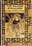
The most famous, and arguably the finest, map of Poictesme is the one drawn by Frank Papé (Hall G2) and first published in 1926, as the endpaper design for the signed, limited issue of the first edition of The Silver Stallion (Hall SS-A1a). See the extended discussion of this map at the G2 Papé link above.
The third "classic" Map of Poictesme was drawn by Peter Koch and published by Ben Abrams at the Argus Bookshop in 1929 (Hall G8). Both the Papé and Koch maps were issued as broadsides. Walter Klinefelter discussed all three of these maps on pp. 24-26 of his Books About Poictesme (1937, Hall E13). The passage is here presented as a PDF. Click on the image at left to access it.
Notes 1, 2, 3: Quotations are from "A Note Upon Poictesme", as printed in the 1928 illustrated edition of The Silver Stallion (Hall SS-D1). The complete text of this Note is available as a PDF, by clicking on the image at the beginning of this section. As usual, you'll need to use your browser's back button to return to The Silver Stallion after accessing it.